 Kham ཁམས་ is one of the 3 main traditional regions of Tibet, along with U-Tsang དབུས་གཙང་ and Amdo ཨ་མདོ་ and is located in the eastern and southeastern corner of the Tibetan Plateau. Kham is a large area covering over 924,000 kilometers² (356,000 miles²) and is more than twice the size of Sweden and more than twice the size of California. Kham is home to approximately 2 million Tibetans or 35% of the total Tibetan population. Parts of Kham lie in the eastern portion of the Tibet Autonomous Region (TAR), western Sichuan, southern Qinghai and northwest Yunnan provinces. Read the links below for more detailed information on the specific regions within Kham:
History of Kham
From the 10th century on, Kham was never under the authority of Lhasa for an extended period of time or under direct Chinese authority until the communist takeover in the 1950’s. Kham was also never ruled by a single leader, but was split up into over 2 dozen separate kingdoms each with its own king. In recent centuries the most powerful kingdoms in Kham were those of Muli (modern day Muli Tibetan Autonomous County in southwest Sichuan), Chakla (modern day Dartsendo/Kangding county in western Sichuan), Dege (modern day far western Sichuan), Lingtsang (modern day northwestern Sichuan) and Nangchen (modern day Yushu Tibetan Autonomous Prefecture in southern Qinghai). Part of the reason that Kham never was under the authority of Lhasa was because of the sect of Buddhism followed in Kham. The Dalai Lama, the government and the most powerful monasteries in Lhasa follow the Gelukpa sect of Tibetan Buddhism while older schools of Buddhism such as the Kagyu, Nyingma and Sakya (around Jyekundo) are followed in Kham. The ancient Bon religion is still practiced in Nyingtri Prefecture, also known as the Kongpo region.
In 1939 the government of the Republic of China created Xikang province with Dartsendo (Kangding) as the capital. Xikang covered the far eastern region of Kham. After the Communist People’s Republic of China took control of the region from the Republic of China (Kuomintang) in 1950, Xikang was divided with everything west of the Yangtze River becoming Chamdo Territory and everything east of the Yangtze remaining Xikang province. In 1955, Xikang province was merged into Sichuan province and renamed Garnze Tibetan Autonomous Prefecture. In 1965, Chamdo Territory became part of the newly formed Tibet Autonomous Region and was renamed Chamdo Prefecture.

Mt. Zhara Lhatse near Lhagang ལྷ་སྒང་ (Tagong in Garnze prefecture in western Sichuan) rising above 5800 meters
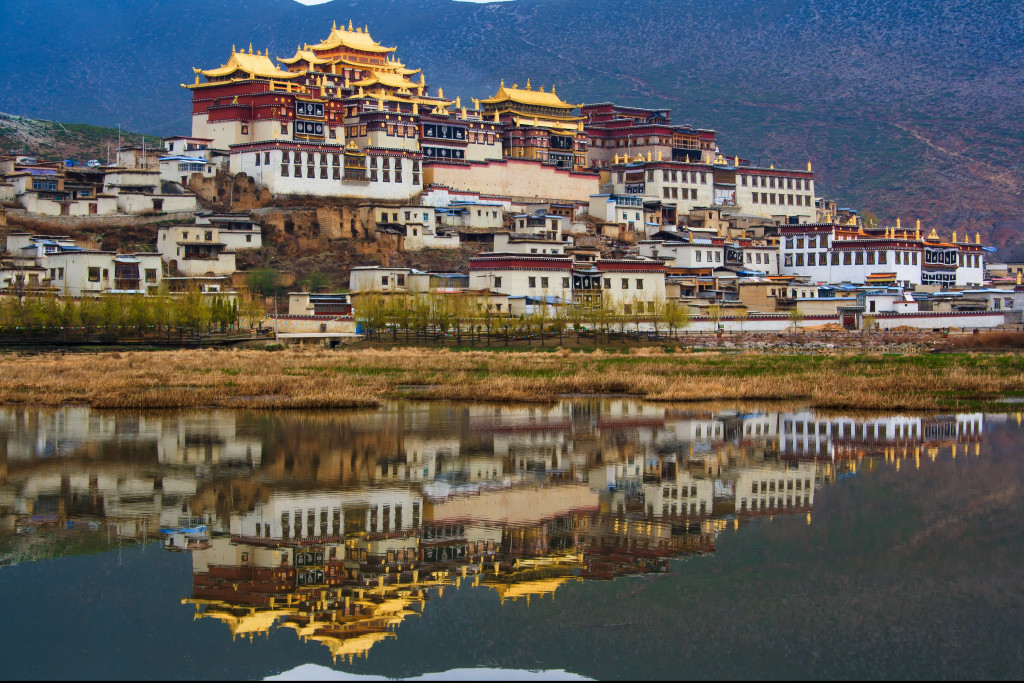
Buddhist monastery in Shangri La, Yunnan
Along the Tiber Leaping Gorge trail in southern Shangri La county, Yunnan

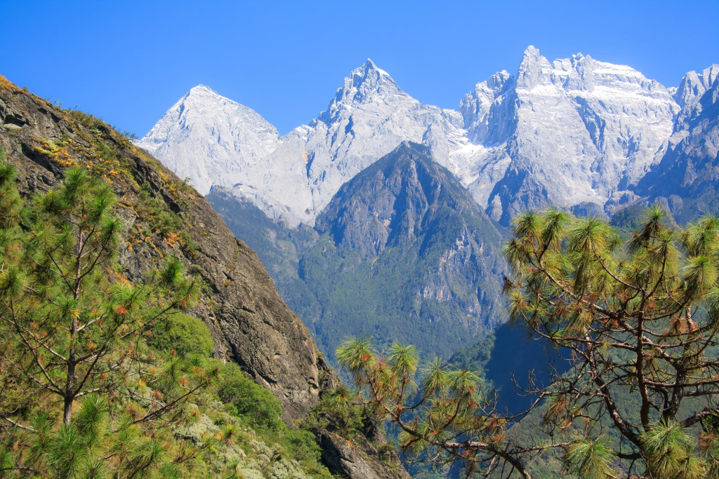
A high pass in Shangri La county in Dechen prefecture (northwest Yunnan)
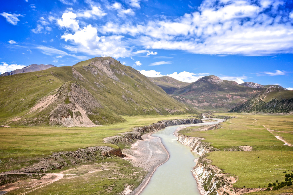
Kham is the most geographically diverse region of Tibet. Kham, traditionally known as Chushi Gangdruk ཆུ་བཞི་སྒང་དྲུག་ which means “4 Rivers, 6 Ranges”, contains the headwaters of many of Asia’s longest and most important rivers. The Mekong, Yangtze, Yellow and Salween rivers all begin in Kham. These rivers cut deep canyons and gorges throughout eastern Kham. There are numerous mountain ranges and high peaks throughout the area. The Kunlun Mountains (which includes the Bayan Har/Bayan Kala Range) form the far northern boundary of Kham while the far eastern extent of the Himalaya’s form the southern boundary. The rugged Hengduan Range, which includes the Daxue Mountains, are along the eastern border of Kham and mainland China. The highest peak in Kham is Minya Konka, which rises to 7556 meters. Other notable peaks in Kham are Mt. Chola, rising to 6168 meters in Dege county and Mt. Bukadaban in Drido county rising to 6860 meters.
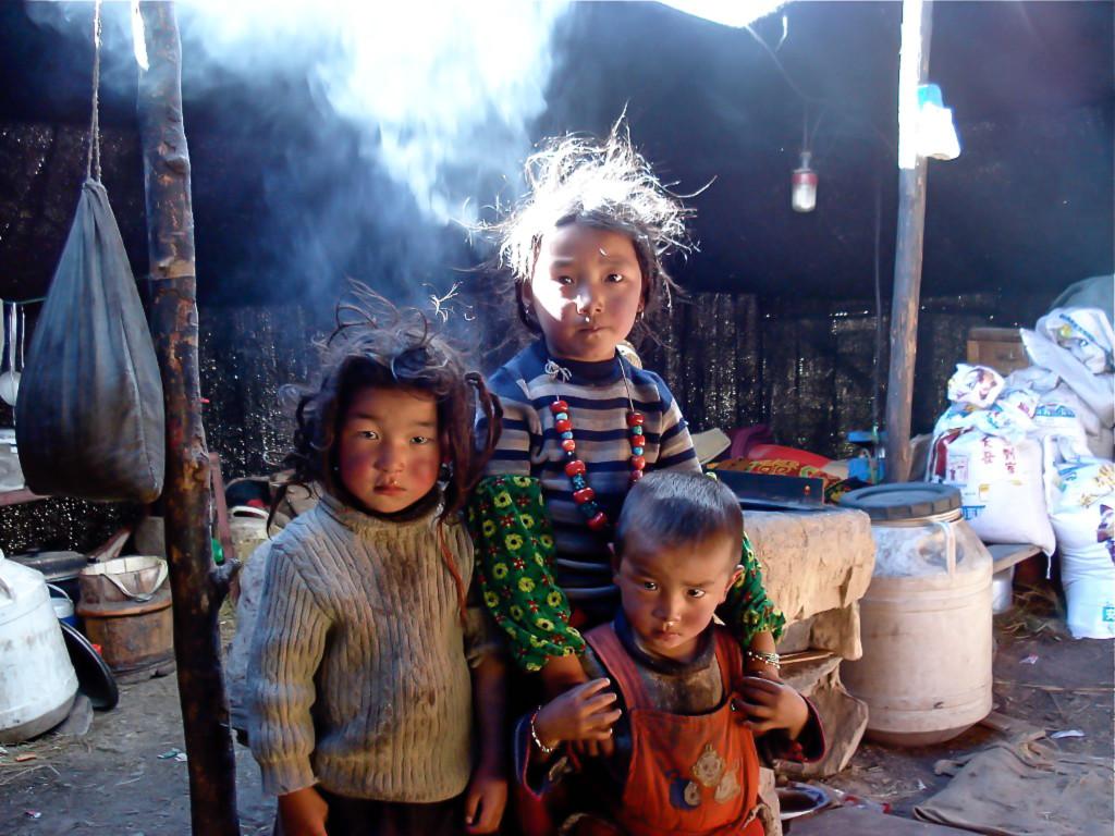
Kham Tibetan nomads in their yak wool tent in Yushu prefecture

Dartsendo དར་རྩེ་མདོ་, one of the largest towns in Kham (Kangding in western Sichuan)

Upper Rashul village in Yushu county (southern Qinghai)

Milk Lake in Dabpa county འདབ་པ་རྫོང་ (Daocheng in western Sichuan)
The far northern parts of Kham found in Yushu (Qinghai) and Nagchu (TAR) prefectures consist mainly of high altitude grasslands that lie between 4200 meters and 4800 meters. This treeless region is sparsely populated and has long, cold winters. Much of northern Kham is permafrost. The few Tibetans who live in this area rely on yak and sheep herding for most of their income. Eastern Kham (Garnze in Sichuan and parts of Chamdo in the TAR) has many deep river valleys that give way to towering peaks. The towns in these valleys lie between 2800 meters and 3400 meters and have a milder climate than northern Kham. Dense evergreen forests are found throughout this area along with fertile farming soil. Southern Kham (Dechen prefecture in Yunnan, parts of Garnze in Sichuan and parts of Chamdo in the TAR) also has evergreen forests as well as plenty of amazing craggy peaked mountains. The elevation in southern Kham is mostly between 2600 meters and 3300 meters.
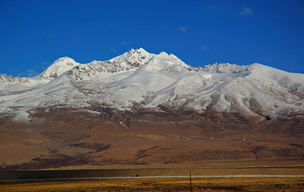
Mountains in Kham along the train line to Lhasa

Kham is found in Yushu, Kardze/Garnze, Chamdo and Dechen prefectures as well as parts of Nagchu and Kongpo
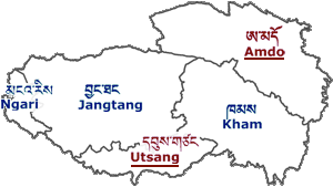
Map showing the traditional regions of Tibet
The Kham Tibetans, better known as Khampa/Khamba ཁམས་པ་, number around 2 million. Khampa are traditionally known as the warriors of Tibet. Whether from Beijing or Lhasa, the Khampa have always been resistant to outsiders controlling their land. Throughout their long history, the Khampa have fought and killed anyone who tried to settle in their region. During the early 20th century, several European and American explorers were also killed by Khampa including Jules-Léon Dutreuil de Rhins, Louis Victor Liotard and Dr. Albert Shelton.
Most Khampa’s are considerably taller than Tibetans from other regions of Tibet. It is not uncommon to come across Khampa men standing well over 6 feet tall. Kham men from Chamdo, Dege and Nangchen often wear their hair long with red or black tassels woven in. Most Khampa men wear earrings. Women from Riwoche, Dege and Jyekundo usually have large pieces of turquoise or coral worn on top of their heads. Throughout Kham, chuba ཕྱུ་པ་ (traditional long coats worn by Tibetans) are fur-lined and made of beautiful material.

Kham man from Jyekundo སྐྱེ་དགུ་མདོ་

Khampa nomad from northern Yushu prefecture (southern Qinghai)

Horse race in Lithang county ལི་ཐང་རྫོང་ (western Sichuan)

Kham man from Jomda county འཇོ་མདའ་རྫོང་ (eastern TAR)

Monks in Dege སྡེ་དགེ་རྫོང་ (western Sichuan)
There are no large cities in Kham. The largest towns are Chamdo, Dartsendo (Kangding), Gyelthang (Shangri La/Zhongdian) and Jyekundo (Jiegu/Yushu). Each of these 4 towns has an airport. An additional airport in Nagchu is scheduled to open in 2015. The nearest large city to Kham is Chengdu, which is the traditional starting point for people wanting to travel the region. The areas of Kham in Qinghai, western Sichuan and northwest Yunnan do not require organized tours, permits or tour guides, though the Qinghai and Sichuan parts do close to political unstableness from time to time. The Kham regions that are in the Tibet Autonomous Region, such as Nagchu and Chamdo prefectures, require a complete organized tour including travel permits, a tour guide, a private vehicle and a driver. NOTE: All 11 counties of Chamdo prefecture have been completely closed to foreign travelers since March 2009.

A Kagyu sect monastery in Chamdo county ཆབ་མདོ་རྫོང་ (eastern TAR)

The SE face of Minya Konka, the highest mountain in Kham rising to 7556 meters

Mountains of Nangchen ནང་ཆེན in Yushu prefecture (southern Qinghai)
Lake Yilhun Lha Tso in Garze prefecture in the Sichuan part of Kham
The main language spoken in Kham is the Kham dialect of Tibetan ཁམས་སྐད་. Kham Tibetan has many sub-dialects and differs so much from northern Kham to southern Kham that speakers from those areas cannot understand each other. The Kham dialect of Tibetan is also, for the most part, not understood by Tibetans from Lhasa or Amdo. There are 4 main dialect groups of Kham Tibetan: Eastern Kham (spoken in eastern Garnze prefecture), Western Kham (spoken in northwestern Garnze and northeastern Chamdo prefectures), Northern Kham (spoken in Yushu prefecture and parts of Nagchu prefecture) and southern Kham (spoken in Dechen prefecture, southwestern Garnze prefecture and southeastern Chamdo prefecture). The Dege dialect of Kham is considered by many to be the “standard Kham dialect”, though most Kham Tibetans in Southern Kham cannot understand this dialect at all.

Dege, the cultural heart of Kham (western Sichuan)

Pelyul Monastery (Baiyu county in western Sichuan)
Garze county in Sichuan Kham in the summertime
All areas of Tibet are amazing and beautiful, but in my opinion Kham is the best region as it offers amazing scenery (nomadic grasslands, glaciated peaks, alpine lakes, evergreen forests and deep river valleys) and equally amazing culture. Some of the best preserved Tibetan cultural areas are located in Kham. It is not the easiest region of the Tibetan Plateau to reach, but it is well worth the effort getting there.
For more information about Kham, send me an email to thelandofsnows@gmail.com

High peak in Dabpa county འདབ་པ་རྫོང་ (Daocheng in western Sichuan)
The upper Mekong River in Dzado county, Yushu prefecture in Qinghai province
Pingback: Kangding « The Land of Snows
Pingback: Tibet Travel Update May 2012 « The Land of Snows
Pingback: Why not Amdo and Kham?? « The Land of Snows
Pingback: Tibet Photography Adventure: June 8th to June 22nd, 2013 « The Land of Snows
Pingback: 2013: Kham Overland Tour | Plateau Photo Tours
Pingback: 2013: Lhasa to Everest Base Camp overland | Plateau Photo Tours
Pingback: Tibet Budget Tour « The Land of Snows
dear sir, Iam a khampa from india . our forefather they came from kham and settled in india years ago may be 200 years.. iam not sure. it is always very nice to read abiut kham and khampas. thank you.
Pingback: Budget Tibet Tour | The Land of Snows
Pingback: Yading Nature Reserve | The Land of Snows
Thank you for your very informative blog and photos. I am excited to read your information as my first thoughts of seeing Tibet were centered on the Lhasa to EBC tours and I am not a group tour kind of guy. Your info on Kham and Ando really intrigue me and I would like help on deciding on an intinerary and associated costs. I will be traveling by myself.
I am going to Bali in late March 2016 and then working my way by train up through Malaysia to Bangkok. From there, I am open to either going overland to north Viet Nam or north through Laos or Myanmar. My time frame would be from early June through late September for this trip to start.
I am very interested in the Buddhist monasteries and the nomadic people’s lifestyle along with the natural beauty of the land and wildlife.
Your help is very much appreciated.
Best regards,
Dave
Hi Dave….Hope you are doing well. I emailed you some detailed info. If you have further questions, please email me at: thelandofsnows@gmail.com
Lobsang
Wonderful Website: I would love to see Shangri La and the Warriors of Kham.
Hello Lobsang,
Did you had news about Tibet Kham reopen for this year 2017? … there is positive news about and they say will start permit application now.
Jose Maria
We have just seen the movie Becoming What I Was which is the story of a young Rinpoche, Padma Angdu Rinpoche who was born in Ladakh, Kashmir. The movie is the story of the young Rinpoche traveling 1,000 miles with his Uncle to try to return to Kham. He is now studying advanced Buddhist studies at a monastery on the Tibetan border near Sikkam. May Rinpoche return to his ancient monastery in Kham. May all beings find peace.
Hello, I would like to use two of the images on this site for a non-profit bi-monthly publication called “Times Of Restoration.” One of the contributors wrote a short report on the Kham Territory. The two images I would like to use are, Dartsendo དར་རྩེ་མདོ་, one of the largest towns in Kham (Kangding in western Sichuan), and Mountains in Kham along the train line to Lhasa. Please advise as to what accreditation should be used. Thank you very much.
Greetings;
I am currently occupied with survey of the Kangding to Nyingchi railroad tunnel route, established in Tongkazhen at this time. Fascinating country and people!
My first visit to Kham was back in the early 80s and it had left me some most fascinating memories of my life. I went back to visit Kham (the W. Sichuan part) last fall/winter, and trekked close to 800 miles to many remote parts of Kram. Its people’s mentality has profoundly changed to what we’d call westernized mindset. The globalization aka westernization has integrated its people to this global marketplace and in the same time has sh$tted this once beautiful paradise and turned its once kind people to profit-seeking soulless global citizens. I guess they got it right: “One World, One Dream” – to get rich quick.