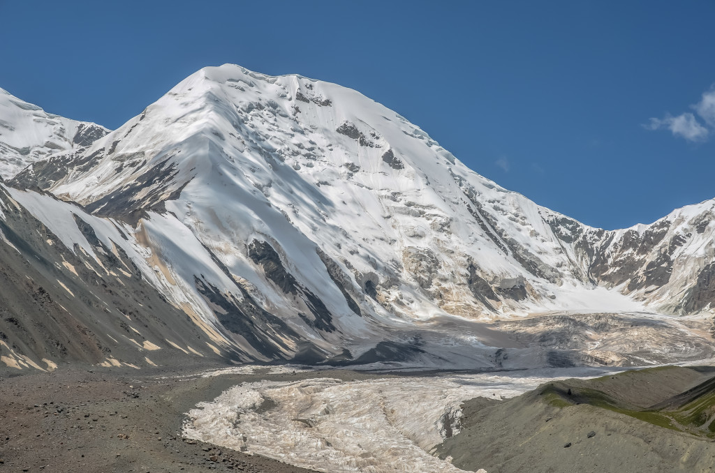
Amnye Machen is one of Tibet’s main holy mountains. It is located in Golok prefecture in the Amdo region (modern day Qinghai). This is a fantastic glacier mountains that offers great trekking!

Read through this update for information on a slightly different route around Amnye Machen: Update on Amnye Machen
Amnye Machen
Amnye Machen ཨ་མྱིས་རྨ་ཆེན་ is the highest mountain in the Amdo region of Tibet and is considered to be one of the holiest mountains in Tibetan Buddhism. It is located in the remote and rugged Golok prefecture in Machen county མགོ་ལོག་ཁུལ་རྨ་ཆེན་རྫོང་ located in southeast Qinghai province. Amnye Machen is part of the Kunlun Mountain Range with the highest point of the mountain reaching to 6282 meters. In 1929, botanist/explorer Joseph Rock traveled to the region and incorrectly measured the mountain at more than 9000 meters. For several years, some people thought that Amnye Machen was higher than Everest. Though by the late 1930’s most people agreed that the mountain was probably under 6400 meters, it wasn’t until the mountain was summited in 1981 by an American team that the exact height was determined.

Nomads along the Amnye Machen range

Monastery on the north side of the mountain

Prayer flags across a high pass on Amnye Machen
There is a 6 to 9 day kora around Amnye Machen that is popular with Tibetan Buddhist pilgrims. Several groups of foreigners also make the trek around the mountain. The traditional starting point of the kora is located near the village of Chuwarna, known as Xue Shan in Chinese, at a large white stupa. This is the place where most Tibetans begin the clockwise journey around the mountain. Beginning from the traditional starting point, the trek around the mountain is about 105 kilometers in length, ending back near the stupa at the starting point.
Another starting point of the trek is outside the small village of Tawo Zholma, known in Chinese as Xia Dawu. From here, the trek follows a motorable dirt road along the northeast face of the mountain for around 58 kilometers. About 2 1/2 kilometers before reaching the village of Chuwarna (Xue Shan), the road leads south for about 20 kilometers. After about 12 or 15 kilometers, the motorable road ends and turns into a trekking trail. The trail then leads northwest towards Tawo Zholma (Xia Dawu) along the southwest face of Amnye Machen. In total, starting and ending the trek in Tawo Zholma covers about 132 kilometers.
Most of the trek is between 4150 meters and 4620 meters. There are two high passes along the kora, one on the north side and one on the south side of the mountain that each rise a little over 4600 meters. During the summer months of July and August, rivers can be quite high and flow fast, especially if there has been recent rain or snowfall.
For a detailed map of the trek around Amnye Machen, go to the following map, which was created by Jon Aldridge (thank you Jon for the great map!!):

Amnye Machen viewed from near Chuwarna (Xue Shan)

Nomad Tibetans around Amnye Machen

Pilgrims prostrating along the kora of Amnye Machen
Getting to Amnye Machen is not very easy as no public transportation goes to the mountain. There are 2 ways to get to the mountain. The first is to take a public bus from Xining to Machen རྨ་ཆེན་, the capital of Golok prefecture. Machen, known in Chinese as Dawu, is located 440 kilometers southwest of Xining. There are multiple buses per day that go between these two places. In Machen, you will need to either take a seat in a shared mini-van taxi or hire a vehicle to take you a further 80 kilometers to the small village of Chuwarna (Xue Shan in Chinese) where you can begin the trek. If you are not wanting to trek, but want a good view of the mountain, you will need to travel an additional 30 kilometers past Chuwarna (or 110 kilometers from Machen/Dawu) up to the high pass where the glacier comes close to the road. You can make the 220 kilometer roundtrip journey from Machen/Dawu to the high pass where the glacier is in one long day.
The other option is to take a public bus from Xining to Mado རྨ་སྟོད་ (Maduo in Chinese), but get off the bus in the small town of Tsogyen Rawa (Huashixia in Chinese). Tsogyen Rawa is 415 kilometers southwest of Xining. There are multiple buses per day from Xining to Mado, but remember to get off the bus in Tsogyen Rawa/Huashixia, which is about 75 kilometers north of Mado. If you decide to go to Mado first, there are numerous shared mini-van taxi’s that depart each day to Tsogyen Rawa/Huashixia. From Huashixia, you will have to hire a shared mini-van taxi to take you the 48 kilometers to Tawo Zholma/Xia Dawu to begin the trek or 75 kilometers out to where the glacier comes close to the road at the high pass. The road past Tawo Zholma/Xia Dawu can be extremely rough and even impassable after heavy rains or heavy snows.

Foreigners on an organized trek around Amnye Machen using yaks

Small village near the Amnye Machen glaciers

Pilgrim tent at a high pass along the south side of Amnye Machen during a summer snowstorm.

Village of Tawo Zholma, known in Chinese as Xia Dawu, with Amnye Machen in the background

Monastery along the Amnye Machen kora

Overlooking Chuwarna/Xue Shan village near the traditional starting point of the kora around Amnye Machen
Despite being the highest mountain in Amdo and being incredibly beautiful, Amnye Machen sees surprisingly few foreign travelers. There are no decent hotel options in the area and if you plan to do the trek, make sure you bring all of your own camping gear and food before arriving. Since most of this area is between 4200 and 4600 meters, the weather can be quite cool and even cold year round. Light snow flurries are common throughout summer while spring and fall can bring heavy snow (up to 1 meter deep). Winters are generally dry, but can easily reach -30C along the high passes.
If you are looking for an off-the-beaten-pathadventure, a trip to or trek around Amnye Machen is it! Feel free to email me for more information about this area at thelandofsnows@gmail.com
Losang བློ་བཟང་

Along the north side of the mountain

Road from Chuwarna/Xue Shan to the mountain

Northeast side of the mountain

River coming straight from the glacier

Me on the glaciers along the north side of the mountain

The road to the mountain from Tawo Zholma/Xia Dawu
Dear Losang
I read your The Land of The Snows website’s articles dated 16 june 2012 regarding the trekking up the Mt Amnye Mache.
I am very interested to know any organised trekking group going up this Mountain around end of Sept 2012 or early October 2012.
I will be taking a long distance train from Shenszhen to Xining city on 23 and expected to arrive Xining on 25 Sept evening and plan to look for trekking group to this mountain.
Can you recommend any organised trekking group to the mountain around 27 or 28 Sept 2012 or early October 2012?
How much is the basic cost of the trekking group to mountain?
How many days required to ascend the mountain?
What is the physical fitness level for a trekker to scale the mount like pilgrims or monks?
What are the basic or essential trekking equipment and clothing required?
Lawrence…I answered you in a personal email.
Have a good day….Losang
Dear Losang,
I have pretty much the same situation here. Could you please be kind enough the copy paste the answer you sent Lawrence to me?
Thank you in advance!
me too :). Also sent you an e-mail… looking forward to your reply and thank you already in advance :)!
Can you please send me the details too… I’d love to do this one day…. Cheers.
Wonderful photos and great detailed descriptions, many thanks for sharing!
Hi Losang!
Can you also send me the information you gave Lawrence? I’m thinking of going in early June 🙂
Thanks!
hi, Losang !……congratulations for site, is wonderful and very useful……I love your country , mountains and landscape….I would like to make this trekking tour september/october 2013; please write me how is possible…
thank you very much !
Me and two other friends want to go to Amnyemachen and do the half kora in July. One of my friends speaks fluent Amdo, and we all speak good Chinese. Do you think it’s possible to just trek by ourselves? Or is it possible to hire a guide in Dawu?
Tours from Xining are a little beyond our budget….
Thank you so much.
Hi. Your photos look really good. I’m planning to go to Amnye Machen trek in August. Would be great if you could share any information regarding cost of the trek, and if you have any recommendations for trek agencies etc. thanks a lot!
P/s: checking my previous got sent?
awesome photos, now i might wanna go this trek!! can you maybe send me info of your trekking groupe??
rune:O)
Hey,
superb photos and report of your trip! As the others i would also be interested in detials about organizing the trek you gave Lawrence.
Thank you in advance!
Gerald
Hey Losang,
Amazing! I am also interested in detials about the trek you gave Lawrence.
Thank you very much!
Talia
Talia,
It is best to email your questions to me at thelandofsnows@gmail.com
Thanks!
Losang
Pingback: Gado Jowa: Tibet’s hidden holy mountain « The Land of Snows
Pingback: Update on Amnye Machen « The Land of Snows
Hi, I’m interested in doing some hiking in Qinghai next month, around 17th August onwards. I’ll be alone, so if there are any group treks going on I’d be keen to hear about them.
all the best,
Chris
Dear Lobsang,
your reports and photos are really impressive, thank you very much for sharing this information. As a we are planning to go to this region in June this year I wanted to ask for some details about organizing the trek – maybe similar information you gave Lawrence – if it is still up to date.
Thanks a lot in advance,
Bernhard
Feel free to email me your questions on Amnye Machen: thelandofsnows@gmail.com
Lobsang